A detailed description of the environmental resources and values of the Cambridge Gulf area is presented in Referral Report No. 2 – Setting & Existing Environment, in accordance with the Environmental Factor guidelines of the WA Environmental Protection Authority (EPA).
All environmental resources and values were mapped within a defined Local Assessment Unit (LAU), which covers an area of 2,800 km2 (typical marine LAU’s referenced in the EPA guidance are 50 km2). The very large LAU does not imply potential for impacts throughout the area, but reflects Boskalis’ conservatively precautionary approach to assessment, ensuring that all relevant environmental resources and values of the general area are included.
The environmental resources and values of the Cambridge Gulf area are summarized as follows:
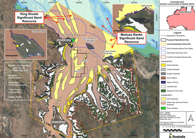
Sand resource:
There is a minimum volume of 300 million m3 of sand in the proposed operational area (POA), derived from ongoing terrestrial sources in the catchment. This is a small proportion of the total sand resource present in Cambridge Gulf overall. The seabed sand comprises large dunes with highly-dynamic sand waves, with vertical heights ranging from 1 to 8 m and horizontal wavelengths of between 50 and 200 m. Repeat hydrographic surveys measured horizontal migration of the sand waves over distances of up to 10 m in just 27-days over a lunar tidal cycle.
Benthic communities & habitats (BCH):
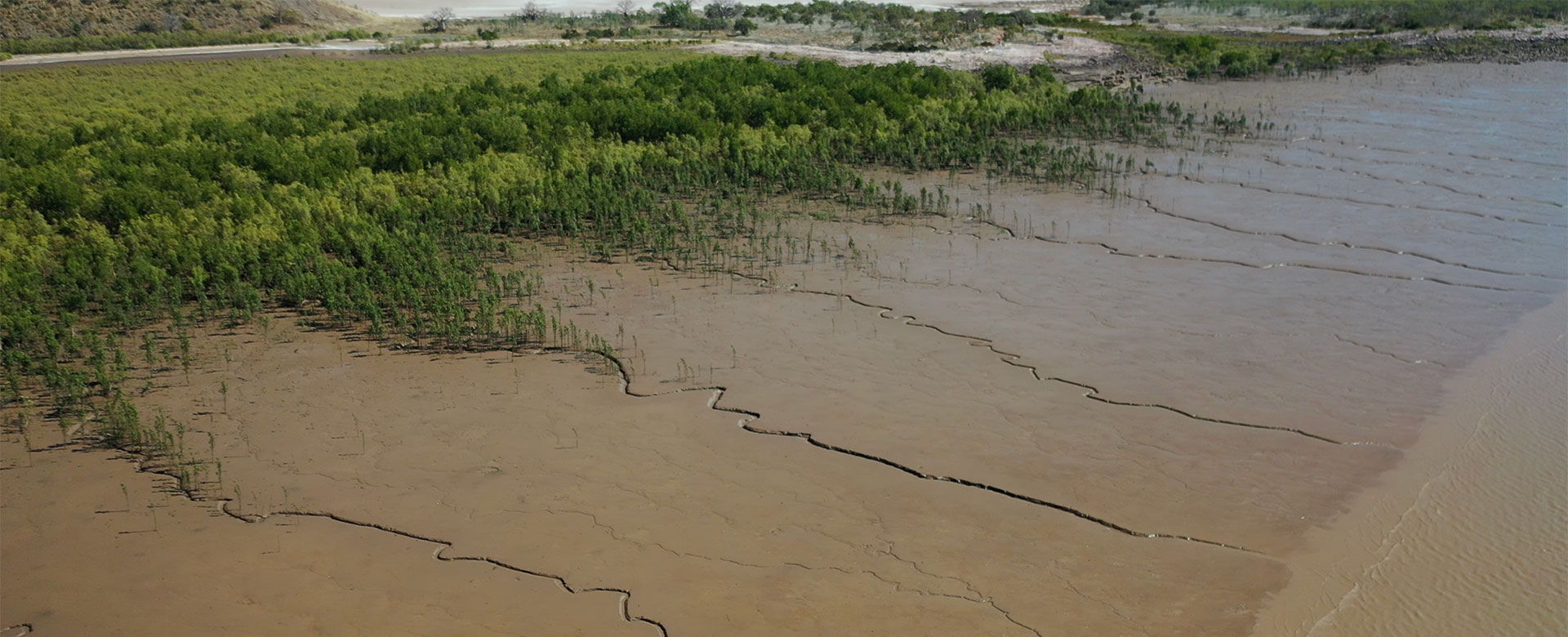
Extreme environmental conditions in Cambridge Gulf including an 8 m tidal range, strong tidal currents, very high turbidity, constantly moving seabed substrates, a permanent lack of light at the seabed and major pulses of freshwater and sediment inputs during the wet season, significantly inhibit benthic biota. Coral, seagrass, macroalgae, sponges and similar benthic communities are not present in Cambridge Gulf. The sand substrate within the POA is largely devoid of benthic biota, due to the fact that the sand is unstable and constantly moving, and the permanent lack of light at the seabed. The most significant benthic community in Cambridge Gulf is a narrow band of mangroves found along most of the coast, with a total area of 350 km2, backed by extensive, barren mudflats and salt-flats. The proposed sand-sourcing operation will not impact on mangroves or other BCH.
Coastal processes:
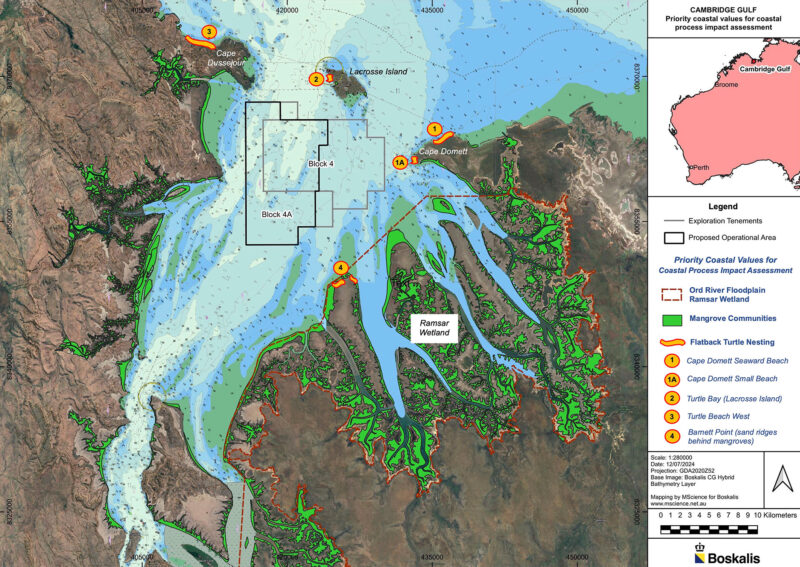
Coastal processes in Cambridge Gulf are driven by the tidally-dominated hydrodynamic system, with inputs of terrestrial sediments from the catchment, including large pulses during the wet season. The most important environmental values that are dependent on coastal processes are the mangrove communities around the coast, and nesting beaches for Flatback Turtles (Natator depressus), mainly located on the seaward coast outside Cambridge Gulf. The proposed sand-sourcing operation will not impact on coastal processes.
Marine environmental quality (MEQ):
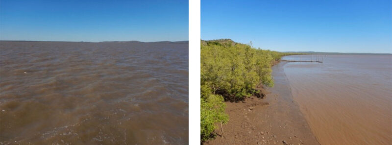
The waters of Cambridge Gulf appear to be free of chemical contaminants, with no significant sources of pollution along the coastline or in the broader catchment. The area has normal sea temperature, salinity and pH, with expected variation between the dry- and wet-seasons. The area has relatively low chlorophyll concentrations, extremely high turbidity levels, and a permanent lack of light at the seabed, throughout the year. The proposed sand-sourcing operation will not discharge any pollutants, and will not affect MEQ.
Marine fauna:
The most significant marine fauna in the Cambridge Gulf area includes a small population of Snubfin Dolphins (Orcaella heinshoni) and Humpback Dolphins (Sousa sahulensis), and a significant nesting beach for Flatback Turtles at Cape Domett, outside of Cambridge Gulf, and lesser nesting sites in the area. Sawfish and river sharks are found in upstream estuarine areas, which will not be affected by the proposal. Dugong are not found in Cambridge Gulf, due to the lack of their seagrass food source. Whales are not found in Cambridge Gulf, due to the shallow waters. Potential impacts on dolphins, turtles and other marine fauna will be prevented and mitigated through the application of best-practice environmental protection measures.
Social surroundings:
The social surroundings of Cambridge Gulf are strongly influenced by the fact that the area is completely uninhabited, with no road access and no infrastructure at all. Non-Aboriginal cultural values including historic shipwrecks were not identified in the POA. Consultation with the TO groups and comprehensive marine surveys did not identify underwater Aboriginal heritage in Cambridge Gulf. There are significant Aboriginal heritage sites on Lacrosse Island and on the adjacent mainland around Cape Domett, which will not be impacted by the proposal. Commercial ships that transit to and from the Port of Wyndham are the main existing economic activity in Cambridge Gulf. The coasts and inlets around Cambridge Gulf are used for recreational fishing.
Protected areas:
There are five protected areas in the general vicinity of Cambridge Gulf, which will not be impacted by the proposal. These are:
- The State North Kimberley Marine Park which starts at the seaward entrance to Cambridge Gulf and extends out to the 3 nm limit of State coastal waters.
- The Commonwealth Joseph Bonaparte Gulf Marine Park located seaward of the State Marine Park.
- The State Ord River Nature Reserve which covers the Ord River Floodplain Ramsar Wetland on the eastern side of Cambridge Gulf.
- The State Mijing Conservation Park located 20 km inland from the east coast of Cambridge Gulf.
- The Balanggarra Indigenous Protected Area which commences 10 km inland from the western coast of Cambridge Gulf.
Matters of National Environmental Significance (MNES):
There are several Matters of National Environmental Significance (MNES) in the general Cambridge Gulf area, which are protected under the Commonwealth Environmental Protection & Biodiversity Conservation Act (EPBC Act). These are:
- The Ord River Floodplain Ramsar Wetland on the eastern side of Cambridge Gulf.
- The West Kimberley National Heritage place on the western side of Cambridge Gulf.
- Several threatened and migratory marine species, including Snubfin and Humpback Dolphins, nesting beaches for Flatback Turtles (mainly outside of Cambridge Gulf), sawfish and river sharks (which prefer upstream estuarine habitats).
Potential impacts on these MNES are assessed in detail in Referral Report No. 7 – Commonwealth Matters. The proposed sand-sourcing operation will not cause direct or indirect impacts on the Ord River Floodplain Ramsar Wetland or the West Kimberley National Heritage place. Potential impacts on threatened and migratory marine species will be prevented and mitigated through the application of best-practice environmental protection measures.
The Local Assessment Unit (LAU) overlain on the Benthic Habitat Map for Cambridge Gulf.
Mangroves around the coast of CG, including the inlets in the Ord River Floodplain Ramsar Wetland; and five Flatback Turtle nesting sites.
Examples of naturally extremely high turbidity levels in Cambridge Gulf.
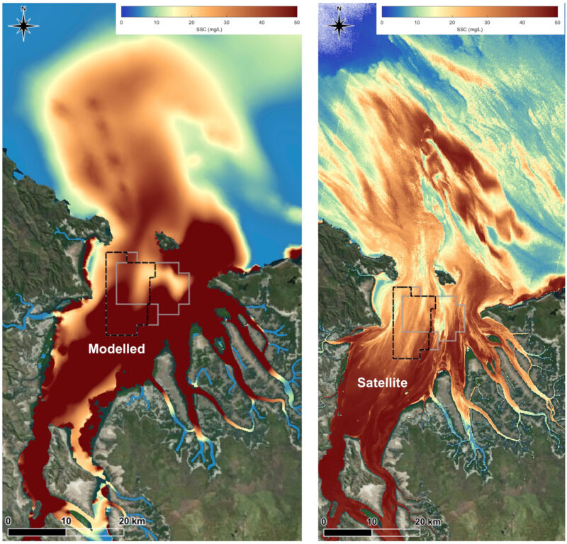
Modelled and satellite-derived suspended sediment concentrations (SSC) in Cambridge Gulf.
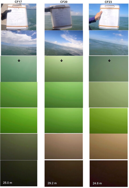
Screenshots from three examples of surface to seabed camera drops in Cambridge Gulf. Camera drops were undertaken at 151 sites and all showed zero light (brown-out zone) at the seabed as per these examples.