To support its feasibility assessment of the Cambridge Gulf Marine Sand Proposal, Boskalis has undertaken a wide range of environmental, engineering, economic and other studies since 2018, as well as a comprehensive stakeholder engagement and consultation process.
Boskalis has sought to achieve as much scientific certainty as possible by supporting the environmental assessments with a very comprehensive suite of studies. This includes sourcing and using a wide-range of pre-existing data from external sources and previous studies of the area, and collecting new data.
Comprehensive site surveys
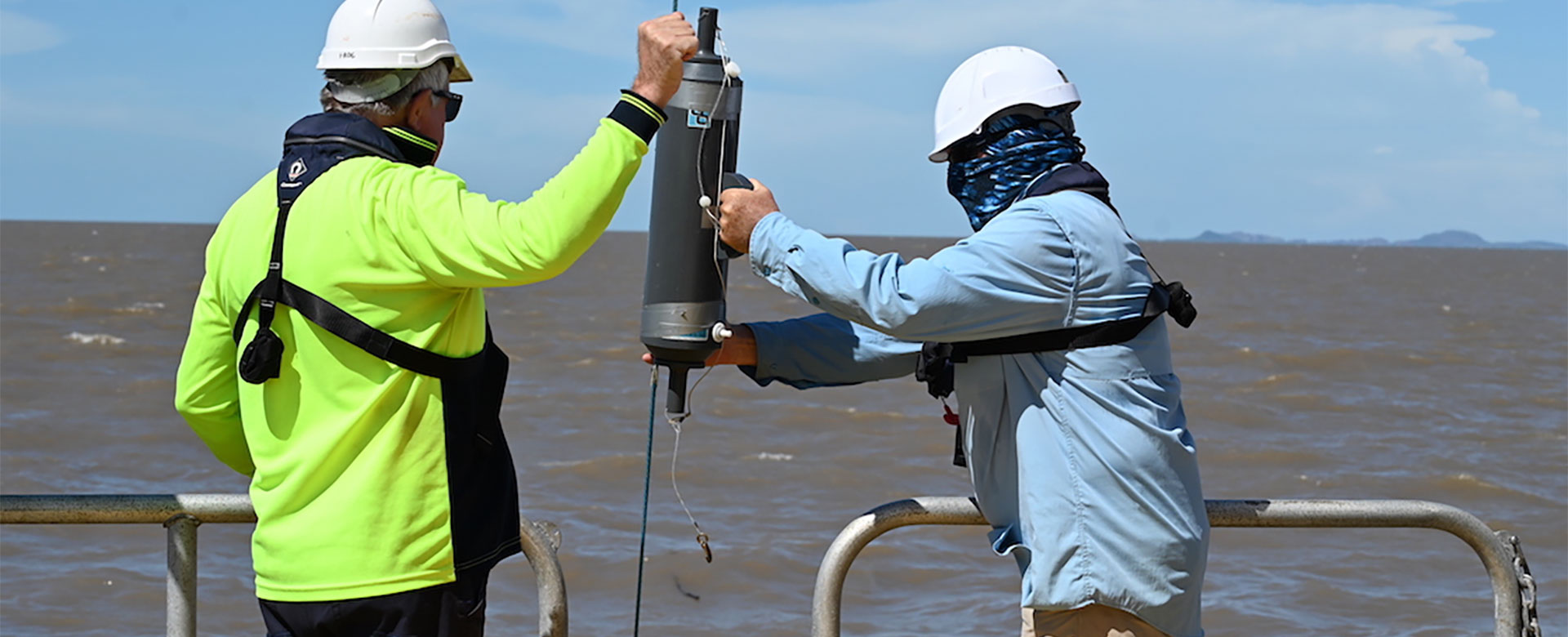
Boskalis commissioned a wide-range of site surveys and field studies to support the environmental assessments, which together constitute an extremely thorough and comprehensive, full-scale environmental impact assessment (EIA), as follows:
- Sand exploration survey February – March 2023:
- Side-scan sonar and sub-bottom profiler surveys.
- Vibro-core sampling of seabed sediments at 35 sites.
- Grab sampling of seabed sediments at 35 sites, to asses both sediment types and benthic biota.
- Drop camera deployment at 17 sites to assess benthic biota and water clarity / turbidity.
- Secchi disc readings at 17 sites to assess water clarity / turbidity.
- Nine days of observations of marine fauna and general environmental conditions.
- Dry season environmental survey July – August 2023:
- Triplicate benthic grab samples at 132 sites and several sites offshore.
- Drop camera deployments at 117 sites and several sites offshore.
- Grab samples of sediments at 21 sites for contamination assessment.
- Vertical water quality profiles at 73 sites plus 30 sites offshore.
- Midwater total suspended solids (TSS) and chlorophyll sampling at 34 sites plus 20 sites offshore.
- Aerial drone high resolution video and photogrammetry surveys of key intertidal habitats at low tide.
- Aerial drone surveys of all beaches and coastal sand areas that could be turtle nesting areas.
- Eight days of dedicated vessel-based marine fauna surveys covering >800 km of transects.
- Twenty days of observations of marine fauna and general environmental conditions.
- Wet season environmental survey February – March 2024:
- High resolution hydrographic survey of the proposed operational area and 1 km buffer.
- Triplicate benthic grab samples at 40 sites.
- Vertical water quality profiles each hour over 13-hour spring tidal cycle at each of three sites.
- Aerial drone LiDAR and photogrammetry surveys of the main turtle nesting beaches in the area.
- eDNA sampling targeting Sawfish and River Sharks at 20 sites.
- Nine days of dedicated vessel-based MMF surveys covering >800 km of transects.
- Nine days of dedicated vessel-based marine fauna surveys covering >800 km of transects.
- Twenty days of observations of marine fauna and general environmental conditions.
- In-situ oceanographic and water quality monitoring June 2023 to August 2025:
- In-situ, seabed-mounted Acoustic Doppler Current Profilers (ADCPs) (measuring current speed and direction, waves and water levels) were deployed at 11 sites for various periods depending on the site, up to 90 days at some sites to give full range of hydrodynamic conditions.
- In-situ seabed light meters and multi-sonde sensors at eight sites, to collect long-term near-seabed light, turbidity, temperature, salinity and pH data.
Supporting Datasets
The main studies and datasets used to support the environmental assessment are detailed in:
- Referral Report No. 4 – Impact Assessments – Annex 1 – Main Datasets.
- Referral Report No. 5 – Full Modelling – Annex 2 – Factual Data Report.
Some of the datasets extend back over many years or decades, which assists in determining seasonal and longer-term environmental patterns and trends. These include but are not limited to.
- meteorological data dating back to the 1950s,
- river level and discharge data dating back to the 1960s,
- tidal data dating back to the 1980s,
- satellite imagery dating back to the 1980s and used to assess coastal changes and derive total suspended matter correlations, to assess long-term trends in suspended matter / turbidity; and
- suspended sediments, turbidity and other physical water quality data collected in Cambridge Gulf by the Australian Institute of Marine Science (AIMS) from 1999 through 2004.
Some of the studies commissioned by Boskalis provide data that had never been collected in Cambridge Gulf previously, which helps to inform general scientific understanding of Cambridge Gulf and will help to improve environmental protection and biodiversity conservation in the area. Such ‘new’ data includes:
- the first known benthic grab sampling in Cambridge Gulf,
- the first known seabed sediment contamination sampling in Cambridge Gulf,
- the first known aerial drone surveys of inter-tidal habitats and turtle nesting areas in and near Cambridge Gulf,
- the first known high resolution aerial drone LiDAR and photogrammetry surveys of the four main turtle nesting beaches in the Cambridge Gulf area, providing a powerful baseline for future monitoring; and
- the first known marine eDNA sampling in Cambridge Gulf.
3D System Modelling
To underpin the environmental assessments, Boskalis commissioned Port & Coastal Solutions to undertake three-dimensional (3D) hydrodynamic, sediment transport and coastal process modelling, using the state-of-the-art DHI MIKE suite of models, which are tailored specifically to assessing potential impacts of dredging projects.
The modelling is reported in Referral Report No. 8 – Full Modelling Report. The modelling found that potential changes to hydrodynamics, sediment dynamics, coastal processes, suspended sediments and turbidity from the proposed sand sourcing are negligible. Potential cumulative impacts were modelled out to 100-years, and were assessed to be negligible.
The datasets used to support the modelling are at least an order of magnitude greater than what would normally be used for similar projects. For example, for a major port dredging project in Australia, a single or perhaps two Acoustic Wave and Current profilers (AWACs) would typically be deployed for a single lunar tidal cycle (a month), to provide data to support, calibrate and validate the hydrodynamic modelling. For this project, seabed-mounted AWACs were deployed at no less than 11 sites, for various periods over nearly two-years.
Collection of this amount of data for this type of project is unprecedented both in Australia and globally. As a result, the modelling achieved an extremely high-degree of accuracy, reliability, calibration and validation.
The modelling assessments were subject to both State and Commonwealth independent, external, expert review, the latter by the esteemed Australian Institute of Marine Science (AIMS). Both reviews found that the data collection program was comprehensive and rigorous, and that the modelling assessments were well calibrated and validated and accurate and reliable
Assessment Findings & Self-referrals
All potential environmental risks were thoroughly assessed, in accordance both the State and Commonwealth impact assessment hierarchy, including the application of best-practice impact prevention, mitigation, monitoring and response measures. The environmental assessment studies find that the proposal is feasible and viable and unlikely to cause significant residual environmental impacts, as presented in Referral Report No. 4 – Impact Assessments.
Despite the low likelihood of significant environmental impacts, as a responsible company with stringent environmental and social policies, Boskalis self-referred the proposal to;
- the WA Environmental Protection Authority (EPA), under section 38 of the WA Environmental Protection Act (EP Act), in September 2024; and
- the Commonwealth Department of Climate Change, Energy, the Environment & Water (DCCEEW), under Part 7 of the Commonwealth Environmental Protection & Biodiversity Conservation Act (EPBC Act), in January 2025.
As a result of Boskalis’ self-referrals:
- On 7 April 2025 the WA-EPA advised Boskalis that it had determined that the proposal would be assessed under the EP Act, and the level of assessment was ‘Referral Information with additional information’ (per section 40(2)(a) of the EP Act). The EPA issued an additional request for information (RFI), and Boskalis provided all necessary additional information requested in the State RFI.
- On 27 June 2025 the Commonwealth DCCEEW advised Boskalis that the proposal was deemed to be a ‘controlled action’ under the EPBC Act, and that the level of assessment was ‘preliminary documentation (with RFI)’ (per section 87 of the EPBC Act). Boskalis provided all necessary additional information requested in the Commonwealth RFI.
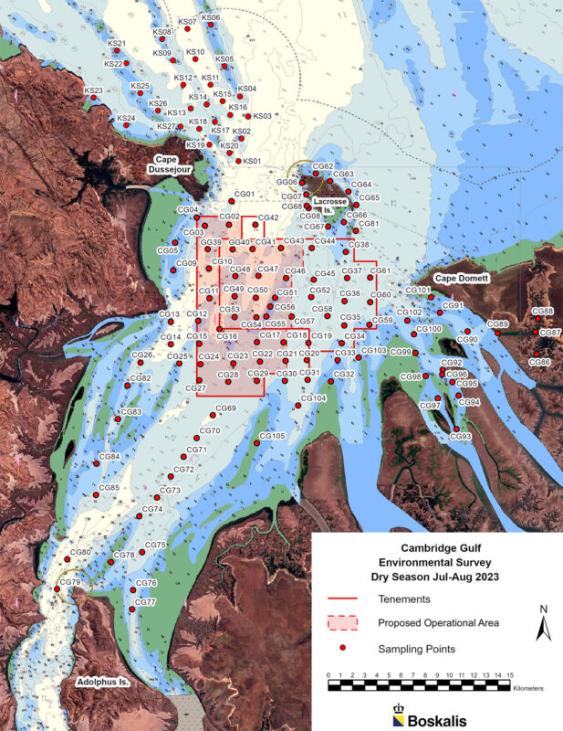
One example of data collection points in Cambridge Gulf. This is a very small component of the much larger suite of datasets collected.
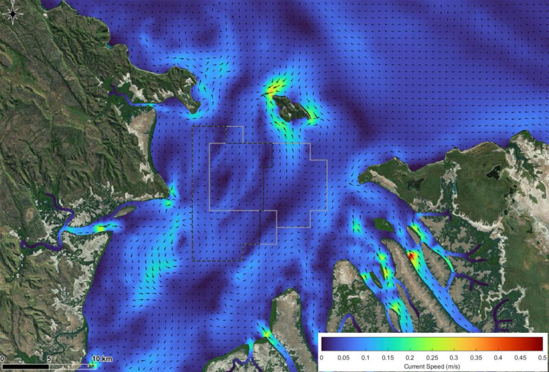
Modelled Currents
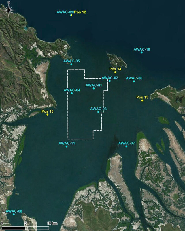
To provide comprehensive data to support system modelling, seabed-mounted AWACs and other sensors were deployed at 11 sites within and outside of Cambridge Gulf, for various periods over nearly two-years.
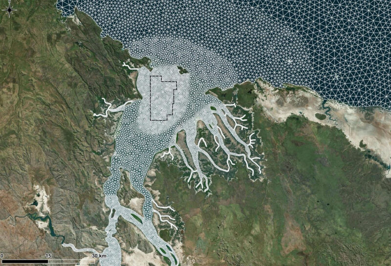
Numerical model mesh used for the 3D hydrodynamic modelling of Cambridge Gulf.